
KP 4
EST: KP4. Emajõe hüdroloogia vaatluskoht alates 1865. aastast
Tartu Ülikooli Meteoroloogia Observatooriumi (Metobs) asutamisega pandi alus ka Eesti sisevete hüdroloogilisele vaatlusvõrgule. Emajõe vaatlusrea alguseks saab lugeda 1. aprilli 1867. Siis fikseeriti kevadsuurvee ajal Emajõe kõrgeim veetase 373 cm üle nullpunkti, mis püsib rekordina tänapäevani.
Kuigi Kivisild purustati teise maailmasõja ajal, säilis paremkalda sillasammas ja veetaseme vaatlused jätkusid seal kuni 1946. aastani, mil silla varemed õhiti. Seejärel oli mõõtekoht vaheldumisi Kivisilla varemeist ülal- ja allpool ning aastail 1953–1963 Kvissentalis. 1971.–1976. aastal oli mõõtejaam Emajõe kaldakindlustuse rekonstrueerimise tõttu ajutiselt vabadussõja mälestussamba koha juures. Alates 20. juulist 1976 asub Tartu hüdromeetriajaam Kaarsillast 80 meetrit allavoolu. 2007. aastal paigaldatud veetaseme ning vee- ja õhutemperatuuri mõõtmise automaatjaama andmed on ühetunnise ajasammuga nähtavad Keskkonnaagentuuri veebilehel.
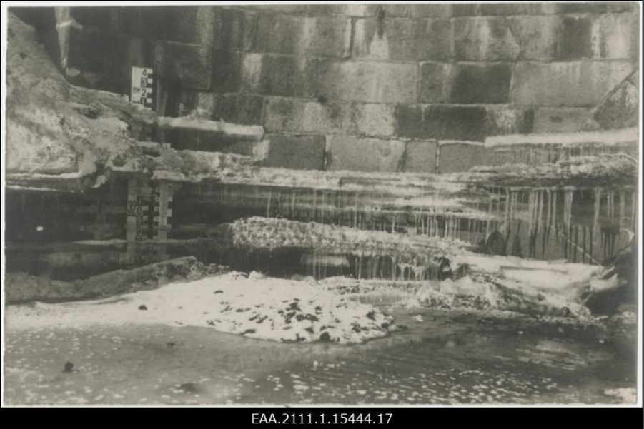
Kuni 1946. aastani oli veetaseme mõõtelatt kinnitatud Kivisilla parempoolse kaldasamba külge
Postimees, märts 1929. Rahvusarhiivi fotoinfosüsteem Fotis (https://www.ra.ee/fotis/index.php/et/photo/view?id=707710)

Emajõe kevadsuurvee kõrgeima veetaseme pikaajaline muutus Tartus aastail 1867–2025. Katkendjoonega on tähistatud pikaajaline keskmine (229 cm üle graafiku nulli), jämeda joonega seitsme aasta libisev keskmine. Lainekujuline joon on kuuenda astme polünoom, mis üldistab veetaseme pikaajalist dünaamikat.
ENG: CP4. Hydrology observation site on the river Emajõgi since 1865
With the establishment of the University of Tartu Meteorological Observatory (Metobs), the foundation was laid for Estonia’s inland water hydrological observation network. The starting point of the observation series for the river Emajõgi was 1 April 1867. During the spring flood of that year, the highest recorded water level of the Emajõgi was measured – 373 cm above the zero point – a record that still stands today.
Although the Kivisild bridge was destroyed during the World War II, the pier on the right bank remained intact, and water level observations continued at the same site until 1946, when the ruins of the bridge were demolished. After that, the observation site alternated between upstream and downstream of the Kivisild ruins, and from 1953–1963, it was located in Kvissentali. From 1971–1976, the observation site was temporarily situated near the Tartu War of Independence Monument due to reconstruction of the riverbank consolidation. Since 20 July 1976, the Tartu hydrometrical station is located 80 metres downstream from the Kaarsild bridge. In 2007, an automatic station was installed to measure water level, water temperature, and air temperature. Its data, recorded at one-hour intervals, are available on the website of the Estonian Environment Agency.

Until 1946, the water level gauge was attached to the right-bank pier of the Kivisild bridge.
Postimees, March 1929. Photo database Fotis of the National Archives of Estonia (https://www.ra.ee/fotis/index.php/et/photo/view?id=707710)
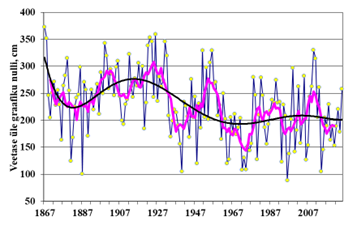
The long-term variation in the highest spring flood water level of the river Emajõgi in Tartu from 1867–2025. The dashed line indicates the long-term average (229 cm above the zero point), the bold line represents the 7-year moving average. The wave-shaped line is a sixth-degree polynomial that summarises the long-term dynamics of the water level.